Detail Garmin Gpsmap 420 S ( Versi Indonesia)
GARMIN GPSMAP 420 S ( Versi Indonesia)
BlueChart® g2 Vision card
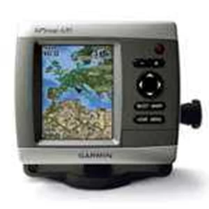
The GPSMAP 420 Si ( Indonesia Version) is a sleek, space-saving chartplotter that features an ultra-bright 4” QVGA display; built-in,
satellite-enhanced worldwide basemap and simplified user operation. The 420 also has an SD™ card slot so you can add additional features with the optional BlueChart® g2 Vision card.
FEATURE
View Satellite-enhanced Maps
The 420’ s basemap contains worldwide satellite images in place of more traditional maps, and its SD card slot makes it easy to add additional maps without connecting to a computer. With fewer keys and a simple, intuitive interface, the 420 makes navigating your way through the water easy.
Add Sonar
Where applicable, the sounder version, GPSMAP 420s, comes with a powerful dual frequency transducer that clearly paints depth contours, fish targets and structure whether you’ re fishing in freshwater or off the coast. The 420 and 420s are also CANet™ compatible, so you can share sounder data with another chartplotter on your boat.
Add Extras with BlueChart g2 Vision
With the optional BlueChart g2 Vision SD card, you can add a whole new dimension of exceptional features to your chartplotter.
* 3D mariner’ s eye view or fish eye view provides you with a 3-dimensional perspective of map information, both above the waterline and below it.
* High-resolution satellite images and aerial photographs help you orient yourself in unfamiliar areas.
* Auto Guidance technology searches through all relevant charts to create a route you can actually follow — one that avoids obstacles, shallow water, buoys and other obstructions.
SPECIFICATION
Physical & Performance:
Unit dimensions, WxHxD: 5.7" x 5.0" x 2.7" ( 14.5 x 12.7 x 6.9 cm)
Display size, WxH: 2.4" x 3.2" , 4.0" diagonal ( 6.1 x 8.1 cm, 10.2 cm diagonal)
Display resolution, WxH: 240 x 320 pixels
Display type: QVGA display
Weight: 1.3 lb ( 590 g)
Battery: none
Battery life: none
Waterproof: yes ( IPX7)
Antenna: internal
NMEA input/ output: NMEA 0183
Maps & Memory:
Basemap: yes
Preloaded maps: no
Ability to add maps: yes
Built-in memory: none ( cannot load maps to internal memory)
Accepts data cards: SD™ card slot
Waypoints/ favorites/ locations: 1, 500
Routes: 20
Track log: 10, 000 points; 20 saved tracks
Features:
Garmin radar compatible: no
Garmin sonar compatible: yes
CANet® compatible: yes
Garmin Marine Network™ compatible: no
Supports AIS ( tracks target ships' position) : yes
Supports DSC ( displays position data from DSC capable VHF radio) : yes
Audible alarms: yes
Tide tables: yes
Hunt/ fish calendar: no
Sun and moon information: yes
3D map view: yes ( optional BlueChart g2 Vision)
Auto Guidance: yes ( optional BlueChart g2 Vision)
Automatic routing ( turn by turn routing on roads) : no
XM WX Weather & Radio for U.S. compatible: no
Voice prompts ( e.g. " Turn right in 500 ft." ) : no
Remote control: no
Headphone jack/ audio line-out: no
Audio/ video input/ output: no
Portable: no
Automotive/ motorcycle-friendly: no
What' s in the Box:
* GPSMAP 420/ 420s*
* Tilt/ swivel mount
* Protective front cover
* Power/ data cable
* Owner' s manual
Contact Person :
Ambar
Hp. 0812 8985 4242 / 0817 6755 161
Tlp. 021-8394 3215
PIN BB 277F253D
Tampilkan Lebih Banyak